The Water Resources Division of North Carolina’s Department of Environmental Quality (NCDEQ) is responsible for protecting, enhancing, and managing North Carolina’s surface water and groundwater resources.
More than half of North Carolina’s population receives its drinking water from aquifers. With a large amount of the state’s groundwater also being used for irrigation, livestock, mining, and other commercial and industrial uses, these demands on groundwater resources drive the need for optimal management of the state’s aquifers.
Statewide Groundwater Monitoring
In order to monitor aquifer supplies and properly assess the impacts of drought conditions, the Groundwater Management team oversees a statewide network of groundwater monitoring wells. Nat Wilson, the Groundwater Management Branch Chief, and his staff are responsible for maintaining and regularly measuring over 630 monitoring wells across the state.
Many of the groundwater monitoring wells have been instrumented with automatic water level recorders that measure and store water level readings hourly, providing data to effectively assess the availability of groundwater supplies. Data is manually downloaded from the recorders, at the site, every few months.
Drought Indicator Wells
Within the statewide network, there is a unique set of wells used for drought assessment. These wells were specifically selected as drought indicator wells, as they respond quickly to rainfall and drought conditions, and provide a good indication of the amount of available groundwater stored in the aquifer.
Because these wells respond so quickly, data needed to be collected and viewed more frequently. It was decided to outfit the drought indicator wells with telemetry systems in order to send data remotely over short time periods, eliminating the need to visit the sites more often.
Solinst Telemetry Systems
Solinst Telemetry Systems were selected for these particular wells. Using cellular communication, STS Systems send data from connected Leveloggers (water level dataloggers) in the field, to a home station computer database at one of the Groundwater Management Branch offices.
With help from technical representatives at Solinst, Wilson and his staff overcame initial cellular signal issues due to topography and remoteness by customizing their STS field stations. They designed aluminum enclosures with a PVC pipe extension used to house an antenna cord. In addition to the antenna, all stations were fitted with a small solar panel to trickle charge the battery powering the STS System.
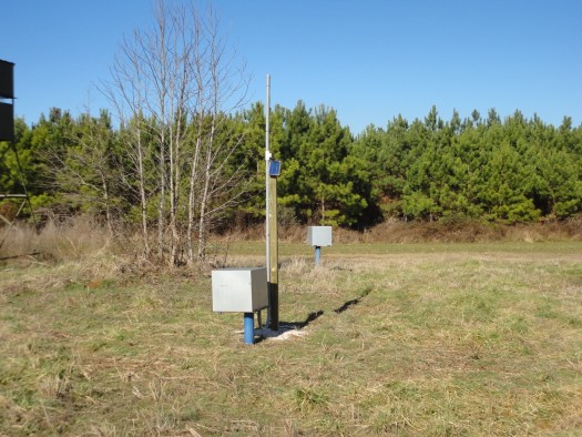
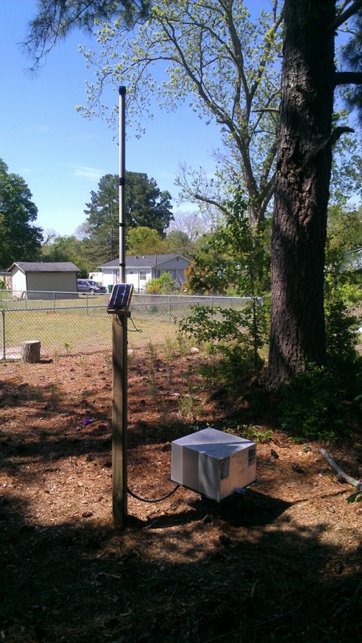
Typical STS Telemetry Field Station Installations on Drought Indicator Wells
Currently, there are twelve drought indicator wells equipped with STS Systems. Each STS field station has a connected Levelogger (water level datalogger), and a Barologger used to barometrically compensate the Levelogger readings. The Leveloggers are set to record water levels hourly; every three hours the STS Systems send the stored data to the computer database, where it is analyzed.
A feature of the STS Systems, which Wilson has found very useful, is the battery voltage readings that come with each data report to the home station computer. This gives them the ability to replace batteries in the field, before low power becomes an issue.
Water Level Data
Data from all monitoring wells in the state network (as well as stream gages) is available to the public on the NCDEQ website; specifically, the drought indicator well data is accessible here: http://www.ncwater.org/?page=345
An example of how the data is being used, the map below shows the location of the drought indicator wells, and their current water levels compared to historical monthly water levels. Below that, is an example of the water level data recorded at one of the drought indicator wells – the most recent data obtained using telemetry.
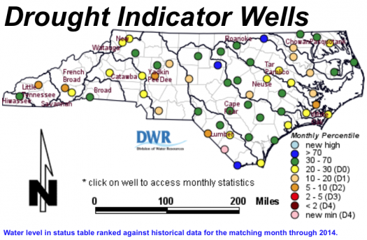
(Image source: http://www.ncwater.org/?page=345)
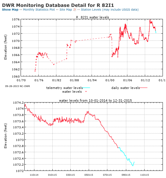
(Image source: http://www.ncwater.org/?page=536&quado=R**82I1)
Overall, Wilson says it is great to be receiving the regular data reports from each Solinst Telemetry equipped well, and that the data has been helpful in gauging drought conditions.
Currently, in partnership with the USGS (United States Geological Survey), half of the drought indicator wells in North Carolina are monitored using telemetry systems. When funding becomes available, Wilson hopes that they can expand the use of telemetry to include all of the drought indicator wells in the remotely connected network.
Solinst thanks Nat Wilson, Groundwater Management Branch Chief, for providing the details of this project.